UPPER YELLOWSTONE MITIGATION BANK
Upper Yellowstone Mitigation Bank

Upper Yellowstone Major Watershed
Upper Yellowstone Major Watershed
Stillwater and Carbon Counties
Wetland and Stream Credits
Wetland and Stream Credits
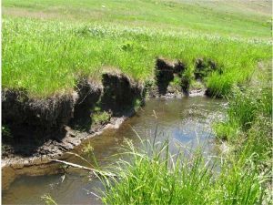
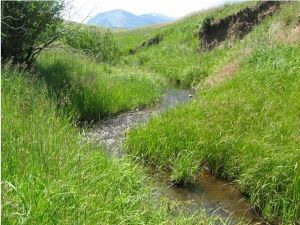
Upper Yellowstone Mitigation Bank is a 367-acre site located along Lazy E-L Ranch in the Stillwater Basin of the Upper Yellowstone Major Watershed in Stillwater and Carbon Counties, Montana. Upper Yellowstone Mitigation Bank was approved by the U.S. Army Corps of Engineers Omaha District in July 2011 for a potential of 21.9 Palustrine Emergent/Palustrine Scrub/Shrub wetland credits and 72,232.3 MT stream credits (includes riparian credits). The mitigation plan includes the restoration and enhancement of 80 acres of wetland habitats and over 57,000 linear feet of streams including Morris Creek, Ingersoll Creek, and West Rosebud Creek.
Upper Yellowstone MB is approved to offset wetland and stream impacts within the Yellowstone Headwaters (HUC 10070001), Upper Yellowstone (HUC 10070002), Shield (HUC 10070003), Upper Yellowstone-Lake (HUC10070004), Stillwater (HUC 10070005), Clarks Fork Yellowstone (HUC 10070006), Upper Yellowstone-Pompeys Pillar (HUC 10070007), and Pryor (HUC 10070008) watersheds, which includes portions of Carbon, Park, Stillwater, Sweet Grass, and Yellowstone Counties.
Determine if your project is located in the bank's service area. DOWNLOAD MAP PDF